Degemer / OBJEKTE / KARSTPHÄNOMENE /
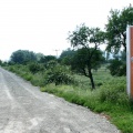
Südliche Ansicht des wassergefüllten Erdfalls Rollsdorf (Foto Dr. S. König – 2007)
9/15
Ment al luc'hskeudennoù
✔ XXS - bihan (240 x 160) )
✔ XS - bihan-kenañ (432 x 288)
)
✔ S - bihan (576 x 384)
)
✔ M - krenn (792 x 528)
)
✔ Skouerenn orin (888 x 592)
)
 - 161_Erdfall-S_Koe.JPG")
- Krouet d'an
- ar Sadorn 19 a viz Mae 2007
- Ouzhpennet d'an
- ar Yaou 29 a viz Kerzu 2016
- Mentoù
- 888*592
- Restr
- 161_Erdfall-S_Koe.JPG
- Ment ar restr
- 102 Ko
- Gweladennoù
- 2728
- Make
- Canon
- Model
- Canon EOS 300D DIGITAL
- ExifVersion
- 0221
- DateTimeOriginal
- 2007:05:19 17:37:36
- FNumber
- 71/10
- ExposureBiasValue
- 0/3
- ExposureTime
- 1/125
- Flash
- 16
- ISOSpeedRatings
- 100
- FocalLength
- 28/1
- WhiteBalance
- 0
- ExposureMode
- 0
- MeteringMode
- 5
0 evezhiadenn