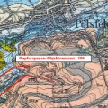
Početna / Oznaka [166] Bachschwinde im Heinischen Tal (Pölsfeld) /
Erläuterung der karstgeologischen Situation im Hainischen Tal
2/3
Veličine fotografija
✔ XXS-sićušan (159 x 240) )
✔ XS-ekstra mali (215 x 324)
)
✔ Malo (287 x 432)
)
✔ Srednje (395 x 594)
)
✔ Veliko (503 x 756)
)
✔ Original (533 x 800)
)

- Napravljen na
- Utorak 3 April 2007
- Objavljeno u
- Četvrtak 29 Decembar 2016
- Veličine
- 533*800
- Datoteka
- 166_Detail_Tafel-NSG_Koe.jpg
- Veličina datoteke
- 77 Kb
- Kategorije
- Poseta
- 2125
- Make
- Canon
- Model
- Canon EOS 300D DIGITAL
- ExifVersion
- 0221
- DateTimeOriginal
- 2007:04:03 14:02:10
- FNumber
- 90/10
- ExposureBiasValue
- 0/3
- ExposureTime
- 1/125
- Flash
- 16
- ISOSpeedRatings
- 100
- FocalLength
- 25/1
- WhiteBalance
- 0
- ExposureMode
- 0
- MeteringMode
- 5
0 komentari