Fotogalerie der Kupferspuren

Willkommen!

Beranda / GEOKARTEN /

137_Haldenlandschaft Neckendorf (nach BRATHUHN 1857)

Brathuhn_Neckendorf.jpg 137_Haldenlandschaft Neckendorf (nach BRATHUHN 1857)Vorschaubilder065_GeoKarte Mönchstollen137_Haldenlandschaft Neckendorf (nach BRATHUHN 1857)Vorschaubilder065_GeoKarte Mönchstollen137_Haldenlandschaft Neckendorf (nach BRATHUHN 1857)Vorschaubilder065_GeoKarte Mönchstollen137_Haldenlandschaft Neckendorf (nach BRATHUHN 1857)Vorschaubilder065_GeoKarte Mönchstollen137_Haldenlandschaft Neckendorf (nach BRATHUHN 1857)Vorschaubilder065_GeoKarte Mönchstollen137_Haldenlandschaft Neckendorf (nach BRATHUHN 1857)Vorschaubilder065_GeoKarte Mönchstollen137_Haldenlandschaft Neckendorf (nach BRATHUHN 1857)Vorschaubilder065_GeoKarte Mönchstollen

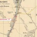
Ausschnitt aus der Karte von BRATHUHN, entworfen im Jahr 1857;

Veröffentlicht am
Mittwoch 16 Januar 2008
Dimensi
2146*1431
Dokumen
Brathuhn_Neckendorf.jpg
Ukuran dokumen
565 Kb
Album
Besuche
2236

0 komen-komen