19/30
Dimensioni delle foto
✔ XXS - minuscola (240 x 159) )
✔ XS - piccolissima (432 x 287)
)
✔ S - piccola (576 x 383)
)
✔ M - Media (792 x 527)
)
✔ Originale (850 x 566)
)

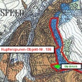
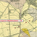
Ausschnitt aus der Karte von BRATHUHN, entworfen im Jahr 1857; Bearbeitet durch Dr. S. König
- Inviato il
- Giovedì 29 Dicembre 2016
- Dimensioni
- 850*566
- File
- 136_Brathuhn_-_Haldenlandschaft_Schloss_Mansfeld.jpg
- Dimensione
- 115 KB
- Album
- Visite
- 1688
0 commento