Fotogalerie der Kupferspuren
Willkommen!
Albumi
Unser Revier
16
VMBH
422
VHM_TMP
138
BILDER
184
SONSTIGE DATEIEN
56
OBJEKTE
1492
ZEITZEUGEN (PERSONEN)
59
ARTIKEL-BILDER
479
PDF - DOKUMENTE
418
GEOKARTEN
154
Sontiges
2
GK-Stollen
12
GK-Hütten
2
Risse
67
GK-Generalkarte
2
Stollen
9
TMP DIASCHAU
712
TMP BILDER IN ERLÄUTERUNGSTEXTEN (TEST)
21
3192 slik
Posebno
Največ ogledov
Novejše slike
Novi albumi
Naključne slike
Koledar
Meni
Oznake
(372)
Išči
Komentarji
(0)
Vizitka
Obveščanje
Prijava
Prijava
Hitra povezava
Uporabniško ime
Geslo
Samodejna prijava
Domov
/
GEOKARTEN
/
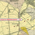
142_Geokarte-Halde Sittichenbach
90/154
Sličice
Nazaj
Naprej
Velikosti slike
Velikosti slike
✔
XXS - zelo mala
(240 x 159)
✔
XS - manjša
(432 x 287)
✔
majhna
(576 x 383)
✔
srednja
(792 x 527)
✔
velika
(1008 x 671)
✔
večja
(1224 x 815)
✔
Izvirna
(1462 x 974)
diaprojekcija
Prikaži meta podatke datoteke
prenesi
Objavljeno
četrtek 29 december 2016
Dimenzije
1462*974
Datoteka
142_Karte_1-GeoKarte-Halde_Sittichenbach.jpg
Velikost datoteke
580 Kb
Oznake
[142] Haldenlandschaft Sittichenbach
Albumi
GEOKARTEN
Ogledov
1841
0 komentarjev
Narejeno z
Piwigo
)
)
)
)
)
)
)

0 komentarjev