12/586
Inicio /

136_Haldenlandschaft Schloss Mansfeld (nach BRATHUHN 1857)

136_Brathuhn_-_Haldenlandschaft_Schloss_Mansfeld.jpg 136_Geokarte - Haldenlandschaft Schloss MansfeldMiniaturas138_Geokarte Haldenlandschaft-Rissd Stollen136_Geokarte - Haldenlandschaft Schloss MansfeldMiniaturas138_Geokarte Haldenlandschaft-Rissd Stollen136_Geokarte - Haldenlandschaft Schloss MansfeldMiniaturas138_Geokarte Haldenlandschaft-Rissd Stollen136_Geokarte - Haldenlandschaft Schloss MansfeldMiniaturas138_Geokarte Haldenlandschaft-Rissd Stollen136_Geokarte - Haldenlandschaft Schloss MansfeldMiniaturas138_Geokarte Haldenlandschaft-Rissd Stollen

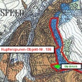
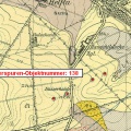
Ausschnitt aus der Karte von BRATHUHN, entworfen im Jahr 1857; Bearbeitet durch Dr. S. König

Dimensiones
850*566
Archivo
136_Brathuhn_-_Haldenlandschaft_Schloss_Mansfeld.jpg
Tamaño
115 Kb
Álbumes
Visitas
2407

0 comentario